Showing posts with label Blowouts. Show all posts

Tuesday, 7 April 2015

Snow Dunes.

Record snow fall made for an interesting field trip to the Provinceland dunes earlier this year. We knew New England had been cold, but leaving Adelaide in 42 C and arriving to -16 C in Boston was a shock to the system. Nevertheless we wrapped up, put our gear together and were fortunately rewarded with some dry, bright and (best of all) windy conditions.

Hope you enjoy the few snaps below from our two weeks in the snow. Thom.


Bowl blowout, Provinceland Dunes, Cape Cod, MA.

Instrumenting our first study site

Scraped dyke structure at Sandy Neck

Lots of sediment still being transported despite the snow
Overnight snow fall. Hey dude... wheres my anemometer?
Patrick wondering where the path went

Team photo!

Wednesday, 16 July 2014

NEW PUBLICATION : Sediment transport patterns in a trough blowout

The trough blowout investigated in the study. (County Donegal, Ireland.)

This study examines the variability of sediment flux and its relationship with near surface wind in a trough blowout. Results demonstrated that sediment flux rates were highly variable even over distances of less than 0.5 m. Where wind flow was steadiest, flux was greatest, consequently highest rates of sediment transport were measured on the erosional walls of the blowout. Interestingly however, correlation between sediment flux and wind parameters was best in the centre of the blowout and poorest on the erosional wall crest.

Authors: Thomas Smyth, Derek Jackson and Andrew Cooper

Published in Earth Surface Processes and Landforms


Sunday, 2 March 2014

How do patterns of wind flow change with wind speed?

Complex blowout that wind flow was measured and simulated over. Each point denotes the location of a 3D ultrasonic anemometer


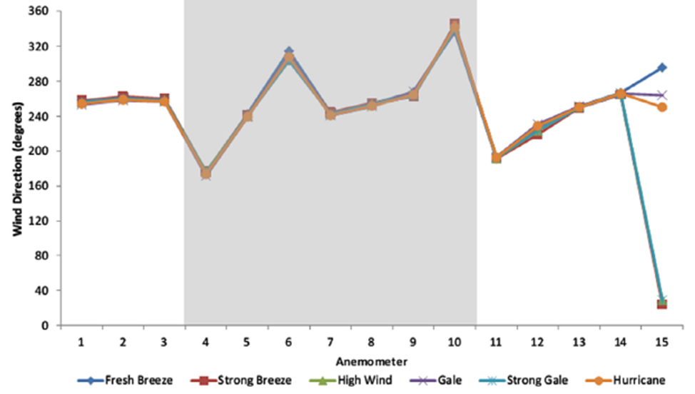
It is sometimes perceived that patterns of wind direction over dunes, including zones of flow reversal and acceleration, change with wind speed. A recent paper by Smyth et al., 2013 published in Aeolian Research found that that patterns of flow steering remained constant even during hurricane force winds.

Measured wind direction at 15 points 


Measurements made by 15 ultrasonic anemometers of wind flow at 1 m above the surface at 15 locations in a complex blowout during from fresh breeze to strong gale found that wind flow steering remained remarkably constant. A validated computational fluid dynamics (CFD) model was then used to simulate flow during hurricane force winds. Wind direction at the 15 points during hurricane force winds also did not vary from those at lower incident velocities.

Simulated wind direction in a blowout during fresh breeze to hurricane force winds


Full Article
Smyth, T.A.G., D.W.T., Jackson, J.A.G. Cooper (2013), Three dimensional airflow patterns within a coastal blowout during fresh breeze to hurricane force winds, Aeolian Research, 9, 111 - 123